Summary
In many exposures of sedimentary rock layers there is a significant gap in age (“unconformity”) between two adjacent layers. This indicates that after the lower layer had been deposited and turned into solid rock, it was raised above water level and exposed to millions of years of erosion, and then sank again below water level to allow the deposition of further sediments which became the upper layer of this interface. Normally we think of erosion creating highly furrowed surfaces. It is therefore somewhat puzzling that the surface between old (lower) and younger (upper) rock layers is often so smooth and flat that it is not obvious that there is an eroded interface there at all.
We address this issue on three fronts. First, we discuss several unconformities in the Grand Canyon which are flat and smooth, at least in spots. Young Earth creationists have argued that these are better explained by rapid deposition in a one-year global Flood than by conventional geology. When these unconformities are examined closely, however, they display features which comport with long ages of tectonic uplift and erosion of solid rock, not with not with rapid deposition of one soft layer atop another.
Second, we review some reasons to believe that in the geologic past it was more common for a wide expanse of land to become eroded down to a near-sea-level “peneplain”, which could provide a flat surface for subsequent deposition of sediments.
Third, we propose a “wave razor” mechanism to explain the occurrence of at least some flat unconformities. As sea level advances on the land, the active surf zone can erode even rugged headlands down to a smooth beach surface. That smooth surface becomes the substrate for subsequent deposition which occurs under the water. Even where there is not a very active surf zone, coastal lowlands may be eventually become flat muddy tidal zones if they are slowly inundated by rising seas, giving a smooth flat substrate for deposition of later sediments.
CONTENTS:
Angular Unconformities
Flat, Parallel Unconformities (Disconformities and Paraconformities)
Four Unconformities in the Grand Canyon
Why Are Many Unconformities So Flat?
Erosion to Peneplains
The Surf Zone “Wave Razor” Can Shave Rugged Landscapes Smooth
Zones of Sediment Deposition Can Move Across a Landmass
Lowlands and Wetlands Can Give Flat Undersea Surfaces
Conclusions
~ ~ ~ ~ ~ ~ ~ ~ ~ ~ ~ ~ ~ ~ ~ ~ ~ ~ ~ ~ ~ ~ ~ ~ ~ ~
Angular Unconformities
In many cliffs or steep hillsides, we can see rocks arranged in more or less horizontal layers. Geologists can estimate the ages of these layers by various means, including index fossils and associated volcanic deposits. In most cases, it appears that the various layers were deposited immediately one after the other, with no big gap in time between layers. However, in other cases it seems that an upper layer was deposited many millions of years after the layer immediately below it.
This sort of time-gapped interface between two rock layers is termed an unconformity. The process of forming an unconformity is most easily discerned when the angles of the layers above and below the interface are different. This situation is termed an angular unconformity.

Siccar Point, Scotland (Photo by Dave Souza; Wikipedia “Hutton’s Unconformity”)
A classic angular unconformity is visible at Siccar Point, on the Scottish coast. The photograph above of this formation shows the interface between steeply tilted (essentially vertical) layers of “greywacke” rock at lower right, topped by nearly horizontal layers of conglomerate and the distinctive Old Red Sandstone (upper left in the picture).
A generic sketch of an angular unconformity is shown below:

Scottish geologist James Hutton first observed this greywacke/sandstone formation exposed in a river valley in Jedburgh in 1787. This interface has become known as “Hutton’s Unconformity”. He had found similar formations earlier, and spent years working out the implications. He realized that this sort of formation visible at Siccar Point required the following sequence of events:
(1) Thousands of feet of sediment accumulated underwater to form what we now see as the greywacke. Even more sediment was laid down on top of that, to compress and cook it to form solid rock layers. Sediments typically derive from the weathering of pre-existing rocks on land, so it would take many years to produce all the sediments we see in the rock layers around us.
(2) This whole assembly was tilted and raised above sea level.
(3) Hundreds of feet (meters) of solid rock were eroded away to form the top surface of the greywacke that we now see as the unconformity.
(4) The greywacke then sank below the waters, and many more feet of sediment were deposited, starting with the conglomerate and the Old Red Sandstone, then more layers on top to lithify them.
(5) Finally, this formation was again lifted above sea level, and many feet of the overlying rock were eroded away to form the present land surface in that area of Scotland.
All of these events cannot be fitted into a one-year Flood, or into any reasonable reconstruction of a 6000-year-old earth. Thus, this one rock formation invalidates the claims of Young Earth (YE) creationists such as Ken Ham of Answers in Genesis that the earth is only 6000 years old, and that the most sedimentary rock layers were laid down in a single Flood. (For more details on this Siccar Point unconformity, see “Unconformities” Showed Geologists By 1800 That The Earth Was Very Old.
Below is another example of an angular unconformity, on the coast of Portugal:

https://epod.usra.edu/blog/2015/01/angular-unconformity-at-telheiro-beach-portugal.html
The lower layers (schists and metagreywackes) were first deposited as sediment under water, and then went through a long period of burial under miles of more sediment, extreme compression and heating and folding deep in the earth, and then the tightly folded, metamorphosed rocks were lifted above sea level and eroded down to a relatively flat surface, which then sank beneath the water and was covered with the sediments which (over many years, and under further sediments) turned into the upper, orange-brown layers of rock visible here. Then the whole assemblage was raised up out of the water and the upper layers were eroded down to expose what is visible in the photo. This formation again demonstrates a geologic history of millions of years, which is incompatible with Young Earth proposals.
For both of these examples, the lower layers were tilted or folded solid rock, and yet normal erosional processes wore down their upper surface to be relatively flat before the deposition of the upper layers.
Flat, Parallel Unconformities (Disconformities and Paraconformities)
With angular unconformities, it is typically clear that there is a major erosional interface at the interface. However, there are other types of unconformities where the upper and lower layers are parallel with each other. In some of these cases, even though all the layers are flat and parallel with each other, there is a clear erosional surface (e.g., some gullies) at the interface. In American geology this is termed a disconformity (the parlance for unconformities is a little different among British geologists). If the interface is essentially flat and featureless, such that the interface is difficult to detect except by the gap in the dates of the upper and lower layers, this is a paraconformity. If the lower rocks are igneous or metamorphic (not sedimentary), the interface is a nonconformity.
The various types of unconformities are sketched in this diagram:

Figure from https://www.thoughtco.com/unconformity-types-and-examples-4123229 . Symbols on the left are for Pennsylvanian age (bottom) and Triassic age (top), separated by at least 50 million years. Diagram (c) 2011 Andrew Alden, licensed to About.com ( fair use policy).
It is worth noting that if you follow a paraconformity for some distance, you typically come to some place where there is clear evidence of erosional processes (i.e., a disconformity):
“Some authors doubt the need for the paraconformity category, arguing that most alleged paraconformities, if traced laterally, eventually exhibit some physical evidence of erosion” (Davis, 1983) [as cited by Prothero and Schwab in Sedimentary Geology (2004), page 131]. Below we will discuss several such cases, where the unconformity in many places is flat and smooth (paraconformity) but in other locations shows clear evidence of long-term erosion.
Four Unconformities in the Grand Canyon
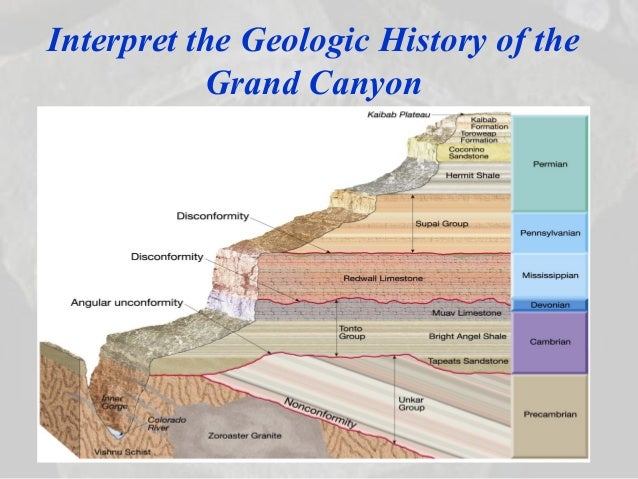
There are over a dozen unconformities among the rock layers of the Grand Canyon, as depicted in Figure 3 of Hill and Moshier’s Flood Geology and the Grand Canyon: A Critique. Here we will focus on four of these unconformities. Three of these unconformities are traced in red in the following diagram, which I will refer to as our “main Grand Canyon diagram”:

Source: Hill and Moshier, https://image.slidesharecdn.com/ch09geologictimefall20071-140429085932-phpapp01/95/ch09-geologic-timefall2007-1-39-638.jpg?cb=1398762127
The lower-most unconformity shown here is between the Tapeats Sandstone/Bright Angel Shale above and the Vishnu Schist and tilted Unkar Group below. This is an obvious angular unconformity, which is known as the Great Unconformity, since it can be traced across much of the North American continent. Widespread unconformities with similar geologic ages can be found on other continents, as well. The surface of the Great Unconformity is fairly flat in many places, but shows more vertical relief in other spots. This interface plainly shows signs of erosion.
The Muav-Redwall Interface
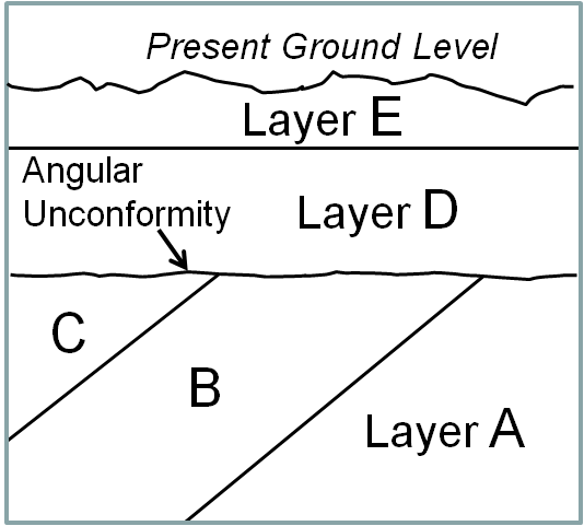
Next up on this diagram is the interface between the Muav Limestone below and the Redwall Limestone above. In many places, this interface is flat and featureless. Young Earth creationists claim that this demonstrates that the Redwall was laid down very soon (within days or weeks) after the Muav, as successive sedimentation events during the one-year global Noahic Flood. They acknowledge that in some places gullies were eroded in the upper surface of the Muav, but claim that these gullies were worn in fresh, soft Muav sediments (again, all as part of one big Flood).
However, the facts show otherwise. We can find hard pebbles of Muav rock deposited in some of these channels. That proves that at the time of the erosion of the channels, the Muav was hard rock, not soft, fresh sediments:
The Muav is separated from the Redwall by a distinct surface of erosion. This erosional surface includes small channels that were scoured into the upper surface of the Muav and filled with Redwall sediments containing small pebbles of eroded Muav. These features indicate that before deposition of the Redwall, the Muav sediments had hardened into rock, risen above sea level, and been weathered to form pebbles and boulders that could be incorporated into the overlying sediments once the sea returned to the area. A global flood would have provided neither time for the sediments to be consolidated nor opportunity for the materials to be weathered by exposure to air. (Davis A. Young, Portraits of Creation, 1990, ed. Howard J. van Till, pp. 68-69).
Here is a sketch of this kind of disconformity, where “Layer C” corresponds to the Muav, and Layer D to the Redwall, and the “Pebbles of C” correspond to the pebbles of Muav rock embedded in Redwall sediments:

Furthermore, there are spots where a third rock formation, the Temple Butte Formation, has been deposited in some of the gullies between the Muav and the Redwall:

Source: Wikipedia, ” Muav Limestone “
The fossils in the Temple Butte indicate that this sediment was deposited in a fresh water environment. This is not compatible with the Temple Butte being rapidly deposited in the midst of a year-long world-wide flood, between the Muav and the Redwall. But this is consistent with a long period (estimated 160 million years) between the deposition of the Muav and the Redwall, with uplift (above sea level) and erosion in between.
The Upper Surface of the Redwall Limestone
Next up on the main Grand Canyon diagram above is the interface between the Redwall Limestone and the Supai Group above. One Young Earth creationist described this surface as “still as flat as a pancake with no evidence of erosion at all”, which is claimed to be at odds with the gap of 15 million years represented by this interface. This creationist characterization is inaccurate in at least two major ways. First (as is common with these unconformities), while the interface may be flat in many places, in other spots there are clear evidences of erosion. There are channels eroded in the Redwall, up to 400 ft deep (see, e.g., Figure 10-6 in The Grand Canyon: Monument To an Ancient Earth, by Hill, et al.). Some of these channels are filled in with deposits of the Surprise Canyon formation, which appears in places between the Redwall and the Supai above. Other channels contain pebbles derived from the Redwall itself, which proves that the Redwall formation had time to harden into solid rock before the erosion of its upper surface. As with the Muav/Redwall unconformity, these pebbles positively show that these sedimentary layers were not all deposited as part of one year-long Flood.
A second major feature of the Redwall is caves and sinkholes, some of which are filled with chunks of fractured Redwall limestone and with shales from the overlying Supai. These features show that after the Redwall sediments were deposited, they solidified into solid rock; then the land rose above sea level (or the sea level fell) to expose the limestone to circulating acidic fresh rainwater, such that caverns were dissolved in the Redwall limestone. Some of these caverns collapsed into sinkholes at the surface. The land then sank and was covered with water so as to deposit the Supai sediments. Again, all this could not fit into a one-year Flood:
Observations by professional geologists indicate the upper surface of the Redwall Limestone, though generally horizontal and conformable with the base of the overlying Supai, has many deep channels scoured into its upper surface – some as much as 400 feet deep. The channels are filled with layered mudstones, sandstones, and limestones and commonly contain pebbles derived from the Redwall. These features indicate that the Redwall lime deposits were hardened into solid rock, lifted up from the seafloor to at least 400 feet above sea level, and there cut by flowing streams that dislodged pebbles from the exposed Redwall land surface and redeposited them in the channels. Still another indication that the Redwall was exposed to the atmosphere for a lengthy period of time – far more than a year – is the existence of caverns beneath, and of sinkholes in, its upper surface. The caverns and sinkholes are commonly filled with red shales from the overlying Supai Group or with angular blocks of fragmented Redwall…The upper surface of the Redwall must have been exposed as land surface for a considerably long time to develop karst topography with sinkholes and caves. (Davis A. Young, Portraits of Creation, 1990, ed. Howard J. van Till, pp. 68-69).
The Hermit Shale/Coconino Sandstone Interface
The Hermit Shale and the Coconino Sandstone are shown near the top of our main Grand Canyon diagram above. The Coconino Sandstone was deposited as wind-blown desert sand, in contrast to most rock layers which formed from sediments deposited under water. The sudden appearance of a very large desert in the middle of a year-long raging global flood is implausible, which furnishes yet another reason to dismiss the Young Earth Flood geology model. (Young Earth creationists recognize this threat, and therefore argue that the Coconino was deposited under water, not as desert dunes. Their claims here may be discounted, since they are based in inaccuracies and deception; see Grand Canyon Creation.)
The time gap between the top of the Hermit Shale and the bottom of the Coconino is not large in geologic terms, perhaps a few million or a few hundred thousand years. This interface is very sharp and flat in many places:

Disconformity between massive Coconino Sandstone and thinner bedded Hermit Shale, Grand Canyon Source: https://geologyscience.com/geology/unconformities/
Unsurprisingly, YE creationists have argued that this flat interface shows that the Coconino was deposited (as marine sediments) immediately on top of the Hermit sediments, with no erosion in between. But as usual, a more complete examination of the facts refutes the YE contentions.
First, the fact that the Coconino is wind-blown, dry, desert sand (with thousands of feet of other rock layers above and below it) militates against any kind of year-long global Flood. Second, in places there are in fact eroded gullies at the interface, up to 8 ft deep. Third, if the Hermit Shale and Coconino Sandstone are traced about a hundred miles south to Sedona, Arizona, we find that these two formations are not in contact at all. They are separated by over 600 ft of a third formation, the Schnebly Hill Sandstone. This again indicates a time gap between the deposition of the Hermit and the deposition of the Coconino, at least in this location.
From the U.S. Geological Survey:
Coconino Sandstone (Lower Permian)—Tan to white, cliff-forming, fine-grained, wellsorted, cross-bedded quartz sandstone. Contains large-scale, high-angle, planar cross-bedded sandstone sets that average about 35 ft (11 m) thick. Locally includes poorly preserved fossil tracks and low-relief wind ripple marks on crossbedded planar sandstone surfaces. Lower 5–20 ft (2–6 m) is intertongued, thinbedded, partly calcareous, flat-bedded sandstone of Seligman Member of Toroweap Formation (Pt). Unconformable contact with underlying Hermit Formation (Ph) is sharp planar, with relief generally less than 3 ft (1 m) but locally as much as 8 ft (2.5 m). Desiccation cracks in the Hermit, as much as 2 ft (0.05 m) wide and 12 ft (4 m) deep, are filled with tan sandstone of the Toroweap or Coconino, mainly in eastern third of map area.
The Hermit Formation was apparently deposited in flat lowlands, including (towards the end, after some erosion) mudflats, which were later covered by drifting desert dunes:
The Hermit Formation forms a red slope below the Coconino Sandstone cliff. Animal tracks, mud cracks and raindrop imprints prove that the Hermit was often exposed to air. At other times, floods brought in siltstone and limestone pebbles. Hermit Formation fossils include invertebrate tracks and trails, insect impressions including a large dragonfly, and many types of worm burrows. There are also plant fossils in abundance, especially ferns and conifers. All these fossils and sediments paint a picture of a semi-arid lowland where meandering rivers ran between forested banks.
The very top of the Hermit contains narrow desiccation mudcracks up to 20 feet deep. If these cracks had been openly exposed to rain and weather, they would have filled with mud, but they are filled with Coconino Sandstone. This shows the cracks opened after the Coconino sands blew over the Hermit muds. Under the dry sands, the cracks in the Hermit Formation widened and admitted the sifting sand.

Image source: Claire’s Geology Brief No. 12: Paraconformities and a Pair of Numpties (YouTube: https://www.youtube.com/watch?v=lq-SHBne-xU )
My purpose here in correcting these errors of YE creationism is not to discredit the Bible or the Christian faith. It is YE creationists who discredit the Bible with their wooden principles of interpretation, which lead to the claim that Genesis teaches the world was created a mere 6,000 years ago. This sort of nonsense drives scientifically informed inquirers away from taking Christianity seriously. There are alternative approaches to interpreting Genesis, which are consistent with modern scientific findings. I survey some of these hermeneutical approaches in Evolution and Faith: My Story, Part 2.
Why Are Many Unconformities So Flat?
Unconformities typically involve lengthy erosion of previously-formed rock layers, followed by deposition of new sediment that ultimately turns into new, upper rock layers. When we think of erosion, we often visualize deeply furrowed hills-and-valleys. How is it, then, that so many unconformities appear so flat and featureless?
We will examine two possible scenarios or mechanisms. The first scenario is that the land was widely eroded down to a nearly flat surface (peneplain), just above sea level, over many millions of years. The other scenario is that a significant amount of the “flattening” of the lower rock formation has taken place at or just below sea level, especially in the surf or tidal zone of the encroaching ocean.
Erosion to Peneplains
A classic explanation for these flat interfaces is that over a wide area (hundreds or thousands of square miles or square kilometers) the rock formation containing the lower layers was eroded nearly flat. Presumably this would take many millions of years, and might be accomplished if the area had been eroded down to near sea level. This type of formation is termed a “peneplain”. American geologist William Morris Davis around 1900 proposed that peneplains are an important part of the overall erosional cycle of a landscape.
Since then, peneplains have been the subject of controversy. Scholars have debated how flat they need to be and how common they are. By the late 1900’s the very concept of peneplains was even ridiculed in some quarters. There are few examples of current peneplains that meet all the classic criteria. The northeastern part of Canada is occupied by pre-Cambrian rock formations that have been fairly stable tectonically and have been eroding down for hundreds of million of years. In wide areas of this so-called Canadian Shield, the ground surface is fairly flat and low. However, massive glaciations over the past two million years have complicated the geology there, by scouring the ground and by their weight causing the ground to depress and then to rebound.
Wikipedia notes, “While peneplains are usually assumed to form near sea level it has also been posited that peneplains can form at height if extensive sedimentation raises the local base level sufficiently or if river networks are continuously obstructed by tectonic deformation. The peneplains of the Pyrenees and Tibetan Plateau may exemplify these two cases respectively.” One can find vast areas in the American West and the interior of Australia that are quite flat.
The peneplane concept has come into more favor in the past few decades. There is widespread recognition of geologically ancient peneplains that were later elevated by tectonic forces and hence underwent further erosion that cut deep valleys through the formerly flat surfaces. Also, there is recognition that the past tens of millions of years have been relatively active tectonically, so there has been less chance for a large land area to just sit there in peace and erode down to near-sea-level flatness. Thus, it is plausible that peneplains were more widespread in the past than they are in the current landscape. From a U. Kentucky geography department blog:
But peneplains are making a comeback. This is best illustrated by a report from the Geological Survey of Denmark and Greenland (Green et al., 2013), though the ideas and evidence are also laid out in a number of journal articles by the various co-authors. The report is concerned with development of elevated passive continental margins (think of, e.g., the Great Escarpment of Africa, the eastern Australian highlands, or the main subject of the report, west Greenland). The arguments are strongly dependent on the identification and interpretation of planation surfaces. As these planation surfaces are low-relief, regionally extensive, and are eroded across geological materials of varying resistance, and because the authors present evidence that they were originally graded to sea-level (they were subsequently uplifted), they can be legitimately referred to as peneplains.
… The report also includes a nice review and synthesis of the peneplain concept and its utility in reconstructing landscape evolution. One of the papers they cite is my 2002 paper: Erosion, isostatic response, and the missing peneplains. On the few occasions this paper is cited, it is normally, and not completely unfairly, cited as representing the anti-peneplain viewpoint. The main point of that paper, however, is to attempt an explanation as to why so few (some would argue no) examples of contemporary peneplains exist. The paper acknowledges existence of old planation surfaces that fit all definitions of peneplain other than their role in a Davisian cycle, and that the theory of peneplain formation (i.e., what would happen with long periods of denudation in the absence of substantial changes in tectonics or base level) is sound. This being the case, and with the amount of effort geomorphologists and other geologists have put into searching for peneplains, where are they? Note that this refers to peneplains graded to Quaternary sea-levels, not the elevated planation surfaces identified by Green et al. (2013) and others.
My proposed explanation was based on the dynamical instability of the interrelationships among denudation, deposition, elevation, isostatic uplift, and isostatic subsidence. This implies that no particular state of landscape evolution (peneplanation or otherwise) would persist over long periods in the face of perturbations associated with tectonics, climate, sea-level, or other factors affecting topographic evolution over long time periods and broad areas.
Norman Newell’s field observations of paraconformities likewise led him to believe that in the geologic past (unlike the present), “relative sea-level for long intervals rarely fell far below the land surface of the cratonal areas.” This would lead to “extensive planar erosion or non-deposition near, or below, sea-level for long spans of time”, which in turn would give the flat, smooth surfaces characteristic of paraconformities.
The Surf Zone “Wave Razor” Can Shave Rugged Landscapes Smooth
Ancient peneplain formation may therefore explain some of the flat unconformities which are observed: Perhaps some wide area was flattened down to near sea level by erosion, and then the sea level rose (or the land sank), and the area was covered with water and then deposition of new sediments began.
However, I’d like to offer consideration of another mechanism for the formation of relatively flat unconformities. This is the action of moving ocean or large lake water on the landscape at the water’s edge and in shallow water depths. As illustrated by the series of photographs below, an active surf zone can grind away at the most rugged landforms, and reduce them to fairly smooth beaches, extending into a relatively flat sea bottom. The flattish sea bottom then becomes the substrate for deposition of sediments, which eventually turn into the upper layers of rocks of an unconformity. Note that it does not matter how furrowed is the land above the water, since that is not where the next round of sediments will be deposited; they are only deposited under the water.
I am calling this flattening/smoothing process the “wave razor.” I did not originate this term. I read it in some article on-line some years ago in connection with erosion, and it stuck in my mind as a worthy descriptor. However, I have been unable to locate that earlier reference; I would be grateful if some reader could help me give credit to the proper party for this.

Pobbles Beach, Shire Combe, Wales. Example of rugged landscape being smoothed out by wave action.
And: https://www.summitpost.org/pobbles-beach-from-three-cliffs/573491 .

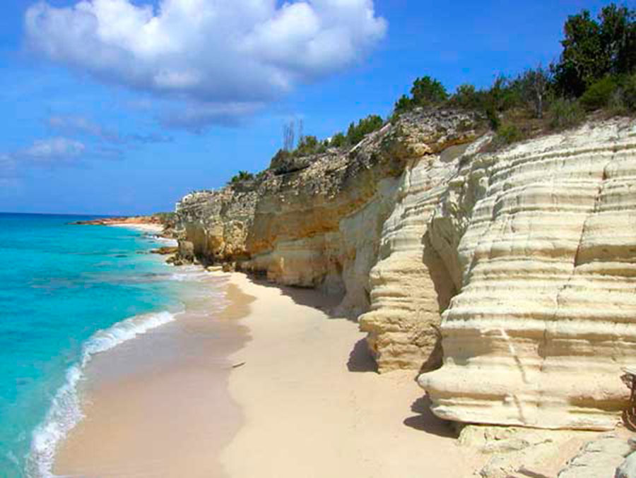
St. Maartens Beach. Example of wave action smoothing landscape. Source: https://www.smaartvacation.com/wp-content/uploads/2015/11/Beach-cliff2.jpg And: https://www.smaartvacation.com/properties/the-cliff-ma9s-oceanfront-condo/

Calvert Cliffs, Chesapeake Bay, Maryland, USA. Example of water action smoothing landscape. Source: https://cdn-image.travelandleisure.com/sites/default/files/styles/1600×1000/public/1504201082/calvert-cliffs-state-park-maryland-MARYLANDBB0917.jpg?itok=v8m3cC9P And: https://www.travelandleisure.com/trip-ideas/beach-vacations/best-beaches-in-maryland .
The three photos above illustrate the power of moving water to “shave” rugged landscapes down to smooth, fairly flat beaches. Note the Calvert Cliffs are exposed to a large inland bay (Chesapeake Bay), not to full ocean surf, and yet a relatively flat beach has been produced. Again, deposition of further sediment that will eventually turn into further rock layers takes place in the water zone, where the sea or bay bottom is fairly flat and smooth. Above the waterline, the cliffs may be deeply contoured, but that is irrelevant, since that is not where sedimentation is taking place.
Beach sand typically consists of grains of quartz, which in turn derives from erosion of sandstones or igneous or perhaps metamorphic rocks. If a wide area consists mainly of limestone or shale, the wave razor can shave it flat and smooth, but relatively little sandy detritus may be formed. Much of the eroded limestone may be dissolved. This may help explain why, for instance, the eroded top surface of the Muav Limestone is topped by another limestone layer (the Redwall), without a sandy beach layer in between them.
Zones of Sediment Deposition Can Move Across a Landmass
As illustrated in the photos above, it is not necessary for a thousand square miles or kilometers to all be eroded down to pancake flatness (peneplain), and then sink beneath the waves for sedimentation to start atop a flat, smooth surface. Rather, the landscape above water level may stay rugged, and yet the “wave razor” can shave the landscape to a smooth undersea surface, which is where the new sedimentation will actually occur.
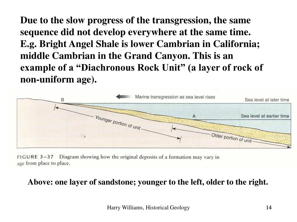
It appears that something like this transpired in the Cambrian era in the vicinity of the Grand Canyon. As the sea level rose, it advanced (“transgressed”) from the west, and eroded pre-Cambrian formations such as the hard Vishnu Schist. As the sea advanced, it first deposited a layer of beach sand (Tapeats Sandstone). This interface between the eroded pre-Cambrian and Cambrian sandstone is part of the Great Unconformity which moved across much of western North America. At any given location, the water level got deeper as the water’s edge moved yet further eastward, and finer sediments were deposited, which turned into shale (Bright Angel Shale). As the shoreline moved ever further eastward and the water at that location became even deeper, limestone (Muav Limestone) was deposited. This sequence is depicted below:
Sequence of rock types expected during a transgression of the sea onto a continent. If you look at time 1, you can see a coastline in cross-section, with sand being deposited closest to shore, mud a little farther out, and eventually carbonate material even farther out. As sea levels rise (time 2), the sites of deposition for these materials migrates landward, putting mud deposition on top the earlier sand deposition and so on. At time 3, the sequence moves even farther landward, resulting in carbonate over mud over sand. Source: https://geologictimepics.com/2012/04/04/great-unconformity-in-montana-and-rising-seas-during-the-cambrian/
It is not the case that the complete Tapeats Sandstone formation was laid down over the whole Southwest, and only then was the Bright Angel Shale deposited across the whole region, and after that was complete, the Muav Limestone was then deposited. Instead, because the zones of deposition moved across the edge of the continent from west to east, the Tapeats was being deposited in the east at the same time (middle Cambrian) that the Muav was being deposited in the west, and the Bright Angel Shale was being laid down in the middle (see line “G” below):

Source: https://www.slideserve.com/ceri/harry-williams-historical-geology-1311736 .
See also Figure 13.15 in Prothero and Schwab, Sedimentary Geology (2004).

Source: https://image.slideserve.com/1311736/slide14-l.jpg And: https://www.slideserve.com/ceri/harry-williams-historical-geology-1311736
Lowlands and Wetlands Can Give Flat Undersea Surfaces
The Vishnu Schist and associated metamorphic pre-Cambrian formations were folded, inhomogeneous, and very hard, and so the wave razor did not shave it perfectly smooth. Although it generally looks fairly flat from a distance, there are places where there are large hills and valleys in the interface (“Great Unconformity”) between the pre-Cambrian rocks and the overlying Tapeats Sandstone. However, softer starting rocks can lead to a smoother beach and underwater surface for further sedimentation, per the three beach photos above.
But what if the land surface was fairly flat to start with, as well as being composed of soft sedimentary rocks? Such is the case with the broad Colorado Plateau region, which includes the Grand Canyon. It appears that this region rose and fell repeatedly slightly above and below water level in the past 500 million years (since the Cambrian), yet has undergone relatively little tilting or folding in that time. Thus, the many layers exposed in the Grand Canyon, and further layers in the so-called Grand Staircase appear to be all fairly flat and parallel.
A step-by-step description of all the deposition and erosion episodes involved here is far beyond the scope of this article. We point readers again to Figure 3 of Hill and Moshier’s Flood Geology and the Grand Canyon: A Critique, which depicts about a dozen unconformities within this series of Paleozoic/Mesozoic rock layers. This means that at least twelve times, the land here went through the full cycle of deposition of sediments, and even more sediments, to lithify at least some of these sediments into solid rock; then the land was lifted above sea level, and some of these rock layers were eroded down. Then the land sank again below water level, and another round of sediments accumulated on top of the eroded rock surface, and these newer sediments became yet another layer of rock.
Typically here the eroded rock surfaces tend to be fairly flat and smooth, prior to a next round of sedimentation. I suggest that the explanation lies partly in the fact that the rocks are relatively soft, and the land was not tilted. If the land slowly rose and sank above and below sea or lake level, spending appreciable time as wetlands or tidal zones, this would lead to a flat surface for subsequent sediment deposition. It does appear that the Grand Canyon region during the Paleozoic era (when most of the horizontal layers were deposited) largely alternated between shallow marine environments, swampy lowlands, and occasional modest uplifts.
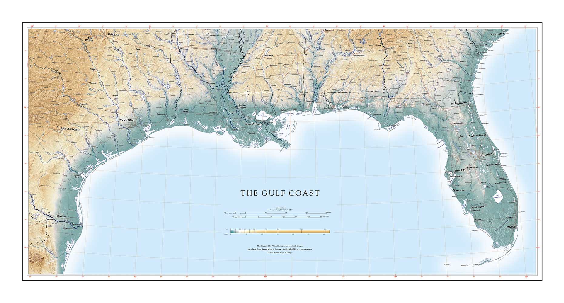
The following figures illustrate the extensive flatness of, for example, the U.S. Gulf Coast coastal plain. Although this is not a classic peneplain, it seems likely that if the water level rose by say 50 feet (15 meters) over the next half-million years, some spot that is currently a gently rolling hill may turn into a swamp and then (impacted by the washing of tidal waters) into a flat beach or flat muddy tidal zone, before sinking deep beneath the water for a new round of sedimentation.

Extensive flat lowlands of the eastern U.S. Gulf Coast (green-blue shading). Source: https://www.ravenmaps.com/mm5/graphics/blog/Gulf_Coast_1000p_HighNEW_1552582051.jpg

Texas wetlands. Source: https://valuewetlands.tamu.edu/2015/04/15/texas-wetlands/

Many of the landscapes we see now, including tidal flats and swamps, are heavily defined by various types of angiosperm flora (flowering plants), especially grasses. But most of these plants, especially grasses, did not exist in the Paleozoic/Mesozoic era, when much of the Grand Canyon deposition took place. The roots of these plants can form tough mats that resist erosion; note how fast a hillside erodes if it lacks vegetation. Absent these modern plants, we propose that rainwater and wave and tidal action were more effective in the deep past at eroding rock layers and scouring soils and other loose material off exposed rock layers, leaving them flat and clean for further sediment layers.
Conclusions
We surveyed several unconformities in the Grand Canyon which are in places quite flat and smooth. YE (Young Earth) creationists have claimed that rapid, successive deposition of (soft) sedimentary layers best explains the appearance of these rock layers today. However, we noted a number of features in these rock formations which are utterly incompatible with rapid deposition of sediments within a one-year Flood. Thus, although we may not currently have complete explanations for why these unconformities are so flat and smooth in places, we know that these features were formed over vast ages, and that the lower rock layers of these unconformities were in fact eroded to relatively flat surfaces before the deposition of the next round of sediments which become the upper rock layers of these unconformities. Even some angular unconformities (which were obviously formed over long ages, with erosion of solid rock lower layers) can sometimes show relatively flat surfaces in places, which demonstrates the smoothing power of erosion by moving water.
There remain questions on exactly how the very smooth interfaces at these and other, similar unconformities formed. Just looking at typical eroded landscapes in the world today, we might expect nearly all unconformities to be deeply furrowed. We proposed two lines of thought to address this issue. First, there are sound reasons to believe that the past tens of millions of years have been unusually active tectonically. Thus, in the geologic past, it may well have been the case that vast areas of land lay only slightly elevated above sea level for extended periods of time. This would lead to more extensive peneplain formation that we see at present. Also, the lack of modern vegetation, especially grasses, in Paleozoic/Mesozoic times may have made landscapes erode more easily back then.
The second line of thought is to note that as the sea advances over eroded land (a) the moving water (surf and tidal flows) at the water’s edge is a powerful agent to shave the land smooth (the “wave razor”) and (b) sediment deposition occurs not on the furrowed land above water level, but mainly on the sea bottom, after the wave razor has passed through that particular tract and left a smooth sea bottom (beach or drowned tidal flat).
ADDENDUM:
Since I posted this article, a related article authored by the pseudonymous blogger Mr_Wilford has appeared, “ Where’s all the erosion? “. The interested reader should see that article. It is too rich in information for me to do justice to it in a brief summary. Mr_Wilford notes that there are a variety of mechanisms for producing flat erosional surfaces which then result in paraconformities in the rock layers.
In particular, it describes the process of marine planation, which I naively termed the “wave razor” above:
Another process still which may well have contributed too flat contacts in the geologic record is marine planation. During marine transgressions, sea level rise is often slow enough that surf zone erosion will often shave off the relief left on an erosion surface rather than preserve the topography (Ollier and Pain 2000, pg. 234). It has been shown that rates of sea level change even as slow as 0.5 cm/1000 years may be sustained for several tens of millions of years, though evidence exists that marine erosion may be able to make similar plains under relatively fast rises of sea level in some instances (Coltori and Pieruccini, 2002), and the maximum possible rate of sea level rise which would allow the formation of a plain will vary from place to place depending on factors such as surf strength and strength of the underlying rock (Ahnert 1998, p. 220). In any case, the resulting surface is one of very low relief called a ravinement surface, and has been documented at many places in the geologic record (Miall 2016, p. 175, p. 373) (Li and Zhu 2014). While some ravinement surfaces may have up to 40 meters of relief on them, most have very little relief (centimeters-several meters). This means many unconformities should be expected to be fairly planar on anything other than the closest outcrop scale. This process is also expected to erode up to 40 meters of the underlying substrate, and so may explain an absence of paleosols or weathering surfaces at many sites.
(Five scholarly quotations in support of this marine planation process then follow in Mr_Wilford’s article).

Nice post! I recently made one about this subject as well (https://mountainrailroadorg.wordpress.com/2022/12/22/wheres-all-the-erosion/)
Micheal Oard is the only YEC I know of to claim that marine planation cannot happen. However, as I detail in my post, of the two sources he gives for this claim one says it is possible during a marine transgression, and the other says it would only be rare, not impossible. Even then, this source (Ahnert 1998) is outdated. He provided no justification for the claim that slow rises of sea level or sufficiently erosive coastlines would be rare, and since the time of writing that, there are hundreds of papers where geologists note areas that widespread marine planation seems to have occurred. Several of the papers I cite in support of this also give independent stratigraphic evidence that the marine transgressions must have been gradual, and so YECs cannot say that conclusion is circularly based on the flat unconformities in question. So it looks like Ahnert’s gut intuition was simply wrong.
Two other processes which can explain the flat surfaces are lateral river erosion, also called panplanation, and backwearing of slopes (pediplanation). Oard likewise tried to respond to these, and his responses were weak. For example, he claimed pediplanation cannot happen because slopes will necessarily adjust their angle rather than retreating at the same angle through time (parallel retreat). But when I spoke to geomorphologists on this issue they were clear that even with slope angle adjustments, pediplans can still form; you’ll just be left with residual lumps on the plain of varying slope angles rather than identical angles. Oard also tried to say that rivers today aren’t currently beveling large plains, but acknowledged mainstream science explains this with recent unusual tectonic movements. He did not try to refute this counter, instead merely claimed it was a “rescue device”.
I also provided plenty of geologist testimony and technical literature references that paleovalleys and the like are pretty common in the geologic record, and are described as common features on nonmarine unconformities. Meanwhile Andrew Snelling admitted in 2009 that Flood Geology cannot produce hill and valley topography on geologic contacts. Some minor channeling sure, but not regional topography.
I appreciate your informative comment, and I enjoyed your article. I added an Addendum to my post above, with a link to your article.
Congrats on finding so many juicy quotes on marine planation. I googled on peneplanes paraconformities and “wave razor”, and could not find much. I did not know that “marine planation” is the official term. (I took two semesters of geology as an undergrad many decades ago, but am just an amateur in this area).
Cheers, and thanks.
Thank you for linking it! I’m an undergrad student at present myself (nearly there though!), but was inspired to make a post after finishing a class in Sequence Stratigraphy where we covered the formation of marine planation surfaces and unconformities in general.
If you want to find more literature on this process outside of what I cited in my post, the terms “transgressive ravinement surface” “wave ravinement surface” “plain of marine erosion” “marine planation” etc. are all good places to start. Typically the first two are the most commonly used terms in post-2000 papers.